

Student Researchers: Le Hoang Phuc (20521762) - Do Huu Khanh Hung (20521361) - Nguyen Tran Linh Dat (20521173)
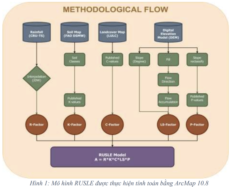
Soil erosion is a serious issue in Dak Lak Province, Vietnam. To assess the extent of soil erosion, we integrated the Revised Universal Soil Loss Equation (RUSLE) model and geographic information system (GIS). Dak Lak is a region with diverse terrain, ranging from high mountains to plateaus and valleys. Clearly, with such characteristics, applying RUSLE to areas with particular attention to the LS and R factors is crucial due to the complex elevation distribution and seasonal rainfall, which significantly impact soil erosion. Other factors such as K and R also have distinct local characteristics compared to the conditions of the original RUSLE equation. Therefore, to use the RUSLE formula, we applied formulas published by Vietnamese authors for areas with similar conditions to calculate the R factor. Establishing a database in GIS: Taking a system approach according to each erosion-affected parameter. To calculate erosion on GIS, the first step is to build a database. Model parameters (R, LS, K) are computed from input data (maps). In this study, the goal is to calculate and create a potential soil erosion map, so we need to calculate the R, LS, K factors. Based on the R factor map, LS factor map, and K factor map to establish a potential erosion map for Dak Lak.
The research results show that there is variation in the degree of erosion across the province, and areas with the highest land loss are mainly concentrated in the north and southeast. Specifically, the areas with the highest soil erosion were identified in the south, especially in the Chu Yang Sin and Chu Mu mountainous areas. Additionally, in the north, Ea H'Leo district is also prominent with significant land loss due to erosion, with erosion rates reaching over 39.5 tons/ha/year in some areas.
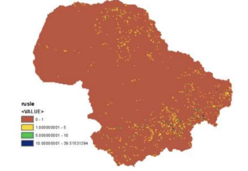
The study also indicates that areas with relatively flat or low-lying terrain, combined with dispersed rainfall during the rainy season, constitute the majority of the natural area of the Central Highlands and are not heavily eroded, accounting for 77.34% of the total area. Meanwhile, hilly and mountainous areas, especially those with low erosion resistance, account for about 18.47% of the natural area, mostly located on hills, low mountains, or on the outskirts of plateaus. These areas have a medium erosion potential, accounting for about 2.78% of the natural area. It can be seen that the influence of terrain and rainfall on erosion is significant, and attention should be paid to managing and protecting land in areas with high erosion potential as analyzed. This information will be the basis for decision-making in land use planning in mountainous regions, helping to minimize erosion risks and effectively protect land resources.
The study also emphasizes the importance of measuring and managing erosion to protect land and water resources. In the context of changing land use becoming an important issue in Vietnam, especially in mountainous areas, this study provides historical information and forecasts land use trends in Dak Lak over the past 20 years. This helps local policymakers make informed decisions, combining economic and social development with environmental protection. Using the Improved RUSLE model and GIS, this research provides an effective tool to assess potential erosion in Dak Lak, supporting policy decisions and environmental management at the local level.
Best regards.
For more information, please visit:
Dong Xanh - University of Information Technology Communications Collaborator